Polar Expeditions to Spitsbergen
Polar Station's location (Svalbard-Arctic)
Calypsobyen
Polar Station of Maria Curie-Skłodowska University (Svalbard)
Arctic
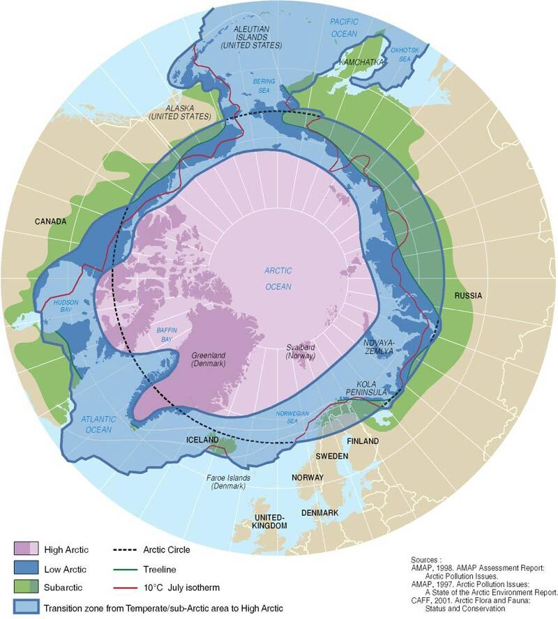
Definitions of the Arctic
Several definitions of the Arctic as a region exist and are all used extensively. Definitions of the geographic boundaries of the Arctic vary, including such definitions as the area with a July isotherm below 10º C, vegetation distribution (tundra) or political boundaries, such as the definition by CAFF (CAFF, 2001). Nowhere else on Earth do we find such vast areas of relatively undisturbed marine and coastal ecosystems.
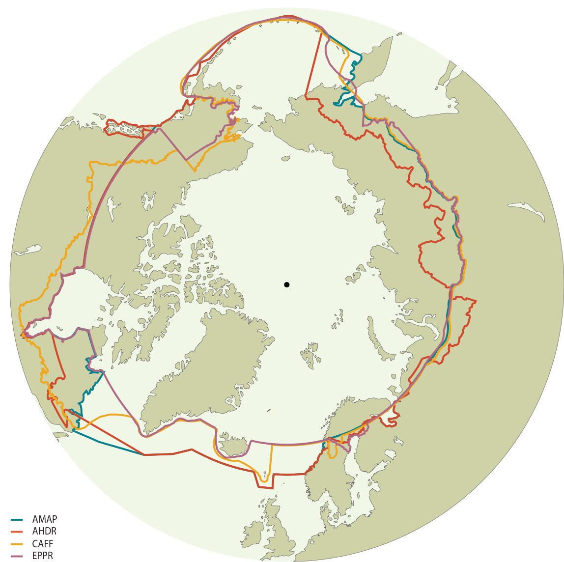
Boundaries of the Arctic Council Working Groups
When defining Arctic regions, it is understood that no single, clear cut boundary exists to delineate their extent. Rather, this boundary will change with its application: environmental, biological, economic, jurisdictional, or social. For example the Arctic Council working groups have different definitions that reflect each of their interests. The Arctic Monitoring Assessment Program (AMAP), which predates the Arctic Council, created its ‘AMAP area’ as the territory where it would carry out environmental monitoring under the Environmental Protection Strategy. AMAP has defined a regional extent based on a compromise among various definitions. The ‘AMAP area’ essentially includes the terrestrial and marine areas north of the Arctic Circle (66°32’N), and north of 62°N in Asia and 60°N in North America, modified to include the marine areas north of the Aleutian chain, Hudson Bay, and parts of the North Atlantic Ocean including the Labrador Sea, excluding the Baltic Sea. Other Arctic Council working groups such as Conservation of Arctic Flora and Fauna (CAFF) and Emergency, Prevention, Preparedness and Response (EPPR), and the Arctic Human Development Report (AHDR) developed their own boundaries or adapted the AMAP boundary. The CAFF boundary largely follows the treeline in order to include the ecosystems that are the focus of its activities. Similarly, the Arctic Human Development Report needed to be based largely on northern political units, as that is how the majority of socio-economic data and information on northern societies is organized. The following map presents the Arctic region boundaries as defined by the various Arctic Working groups noted above (UArctic Atlas: Arctic Boundaries).
Source: GRID-Arendal
Svalbard
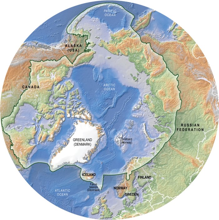
The Arctic represents the northernmost area of the World, the Arctic Ocean and the land areas that surrounds it. The region is characterized but cold temperatures, and ice and snow. The summers are short, but with long periods of daylight (midnight sun). The winters are long and cold and with periods with no sun (polar night). The Arctic Ocean is one basin that is mostly covered by sea ice, and is connected to the Pacific and Atlantic Oceans. The countries in this region are Russia, Finland, Sweden, Norway, Iceland, Greenland (Denmark), Canada and Alaska (USA).
Source: Hugo Ahlenius (GRID-Arendal)
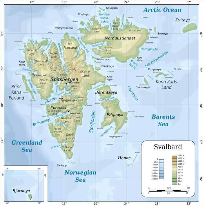
Svalbard are group name of all the islands in the Arctic Ocean which were placed under the sovereignty of Norway by the Treaty of Paris of February 9, 1920. The islands are situated between 74° and 81° northern latitude and 10° and 34° eastern longitude, and comprise Spitsbergen (37 814 km²), Nordaustlandet (14 467 km²), Edgeøya (5073 km²), Barentsøya (1288 km²), Kvitøya (682 km²), Prins Karls Forland (615 km²), Kong Karls Land (331 km²), Hopen (46 km²) and Bjørnøya (178 km²) farthest south. Total area: 61 020 km². Longyearbyen, the administrative centre of Svalbard, is the world’s northernmost permanently inhabited settlement, named after John Munro Longyear (1850-1922), whose Arctic Coal Company started coal mining and surveying operations in Svalbard in 1906. (Source: Polar places names, NPI)
Source-map: Oona Räisänen (GNU FDL)
The main elements of Spitsbergen’s natural environment depend on the bodies of seawater that surround it: the Greenland Sea to the west, the Barents Sea to the east, and the Arctic Ocean to the north. Of crucial importance are also the ocean currents that flow around the island. Warmth in the Arctic region is mainly transported by the West Spitsbergen Current, which is a branch of the North Atlantic Drift. It carries warm and salty Atlantic waters. On the other hand, we have the East Spitsbergen Current, which contains chilled and freshened Arctic waters. Near the island of Hopen, it separates into two distinct currents: Sørkapp and Bjørnøya. The Sørkapp Current flows to the west, passing the Spitsbergen headland (Sørkap Land) from the southern side, and then its waters travel northward. As a result, the climate in individual regions of the island varies significantly. The western part is warmer, and the climate in the inland areas is more continental. As a result, the island experiences significant climate variations among its regions. The western part has a warmer climate, while the inland areas have a more continental climate.

(A) Location of Svalbard (UNEP/GRID‑Arendal); (B) location of study area, with a background of ocean currents: 1 – warm currents (WSC – West Spitsbergen Current), 2 – cold currents (ESC – East Spitsbergen Current, SC – Sørkapp Current, BC – Bjørnøya Current); 3 – glaciers; WJL – Wedel Jarlsberg Land, TL – Torell Land
Spitsbergen provides an excellent setting for interdisciplinary scientific research on its unique natural environment. Such research can be conducted in accordance with the laws of this archipelago. The nature of this land and its accessibility were the deciding factors behind the initiation of Maria Curie-Skłodowska University in Lublin (UMCS) Polar Expeditions in 1986. The chosen location for scientific research was the northwest part of Spitsbergen’s coast, bordering the Greenland Sea and Bellsund to the west and north, and the Dunder Valley, Recherche Fjord, and Recherche Glacier to the southwest.

Study area – NW part of Wedel Jarlsberg Land (Orthophotomap, Zagórski 2005)
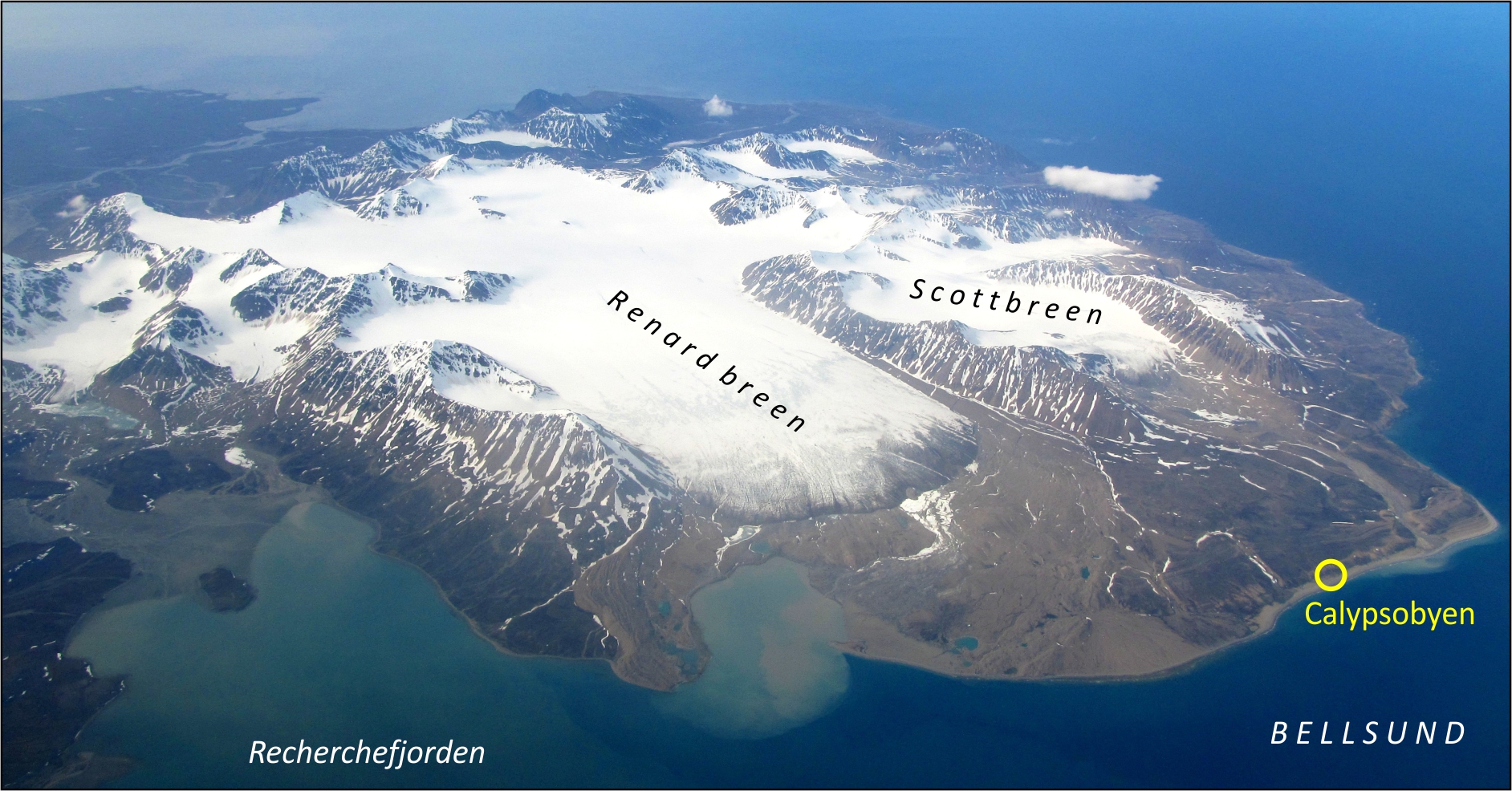
Location of the Polar Station in Calypsobyen (Photo T. Wawrzyniak).
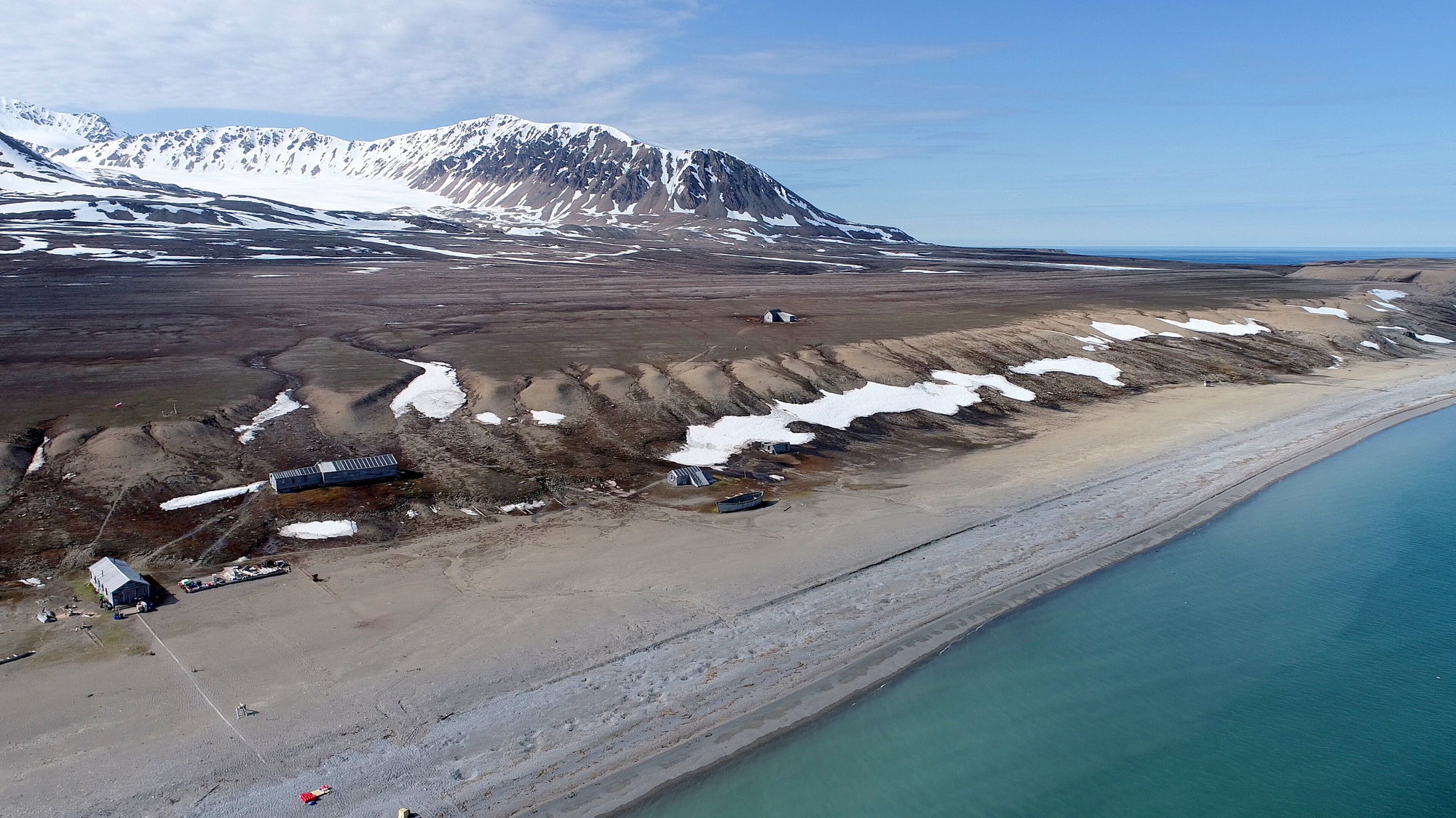
Location of the Polar Station in Calypsobyen (Photo Piotr Zagórski).
Logo

Contact Us
Institute of Earth and Environmental Sciences
Maria Curie-Skłodowska University
al. Kraśnicka 2D
20-718 Lublin
(+48) 81 537 69 96
inoz@mail.umcs.pl
Get Connected
All rights reserved © 2024 Piotr Zagórski